

Quincy Center
1305 Hancock St, Quincy, MA 02169
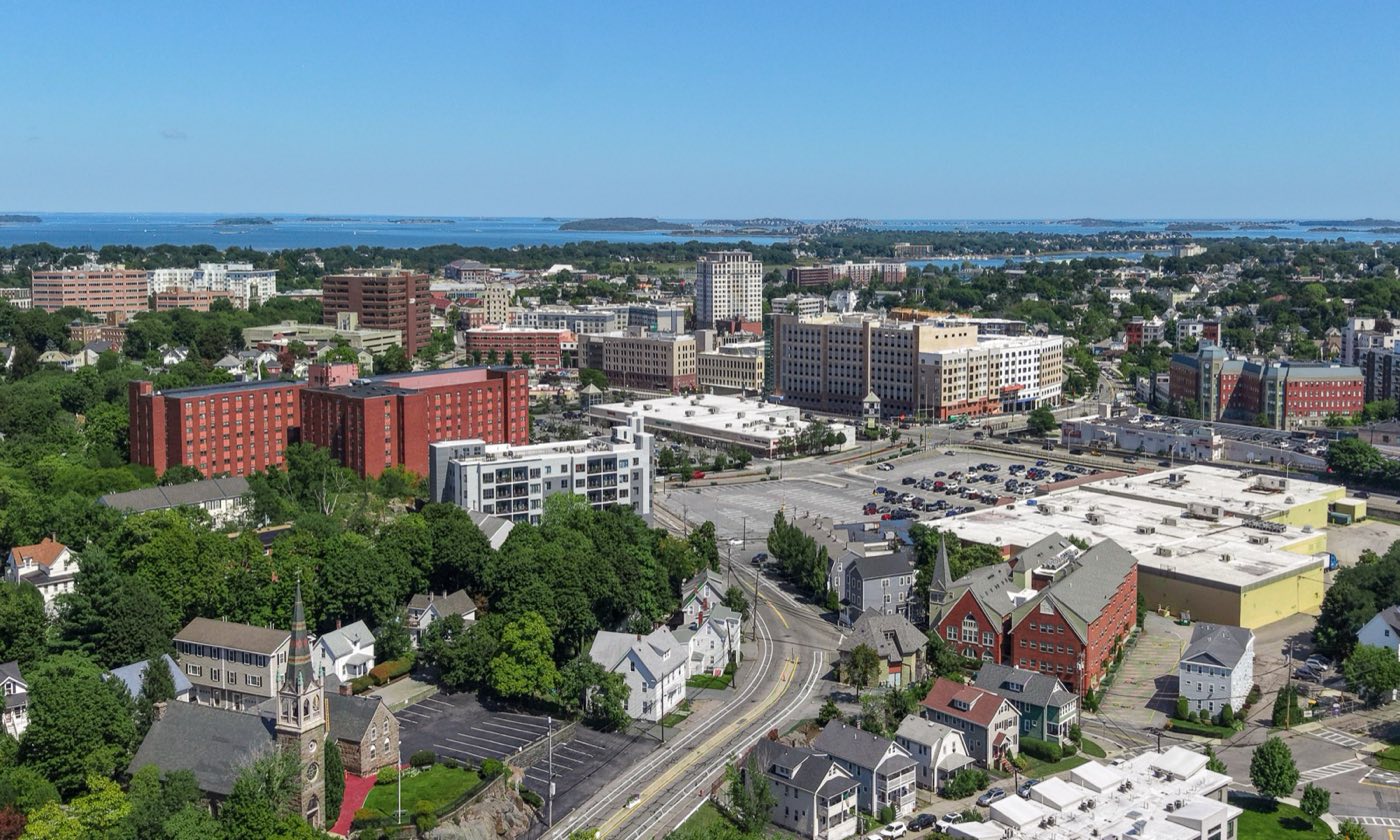
Quincy sits directly south of Boston on the shore of Quincy Bay, bounded by the Neponset River to the north and the Fore River to the east. It was set off from Braintree and incorporated as its own town in 1792, then chartered as a city in 1888. Quincy Center, with the MBTA Red Line running through it, anchors a string of shoreline and harbor neighborhoods including Wollaston, North Quincy, Squantum and Houghs Neck.
Quincy uses several ZIP codes by neighborhood, including 02169 (Quincy Center/Houghs Neck), 02170 (Wollaston) and 02171 (North Quincy/Squantum).
| Area | Zip code | Where it is |
|---|---|---|
| Quincy Center | 02169 | The city's downtown around City Hall and the Hancock Street/Adams corridors, served by the Quincy Center Red Line station. |
| Wollaston | 02170 | A neighborhood on the bay north of downtown, home to Wollaston Beach and the Wollaston Red Line station. |
| North Quincy | 02171 | The northernmost neighborhood, along the Neponset River across from Boston's Dorchester and Milton, with its own Red Line station. |
| Squantum | 02171 | A peninsula neighborhood reaching into Quincy Bay, near Squantum Point Park. |
| Houghs Neck | 02169 | A shoreline peninsula neighborhood on the eastern side of the city, facing Quincy Bay. |
Start with Blue Hills Reservation and Wollaston Beach, then 3 more below.
A large state reservation with wooded hills, ponds and trail networks, reaching into Quincy's western edge. Trails range from easy loops to the rocky summit of Great Blue Hill.
Border of Quincy, Milton and Randolph
A roughly three-mile stretch of beach and boardwalk along Quincy Shore Drive, the largest beach on Boston Harbor, with views toward the Boston skyline.
Quincy Shore Drive, Quincy, MA
A waterfront park on a former naval air station site, with paved paths, harbor views and access to Marina Bay.
Squantum, Quincy, MA
The National Park Service site preserving the homes of presidents John Adams and John Quincy Adams, including the Old House at Peacefield.
135 Adams St, Quincy, MA
Plan a visitA retired U.S. Navy heavy cruiser preserved as a museum ship at the former Fore River Shipyard site.
Fore River Shipyard, Quincy, MA
Quincy was part of Dorchester and Boston before becoming the North Precinct of Braintree in 1640; it was set off as its own town in 1792 and named for Colonel John Quincy.
The Granite Railway, built in 1826 to haul granite from Quincy's quarries to the Neponset River, is considered the first commercial railroad in the United States.
Quincy was a major 20th-century shipbuilding center; the Fore River Shipyard built vessels including the USS Lexington and USS Massachusetts before closing in the 1980s.
Quincy's coastline gives it several miles of harbor beach and waterfront parkland, while the Blue Hills Reservation along its western border adds wooded trails and hilltop views.
3 places in Quincy to try, including seafood / clam shack and waterfront seafood restaurant. No one paid to be listed.
Seafood / clam shack
A family-run seafood counter across from Wollaston Beach serving fried clams, lobster rolls and other New England seafood since the 1960s.
861 Quincy Shore Dr, Quincy, MA 02170 · tonysclamshop.com
Waterfront seafood restaurant
A seafood restaurant and bar on the docks at Marina Bay with outdoor patio seating over the water.
542 Victory Rd, Quincy, MA 02171 · reelhousemarinabay.com
Thai restaurant
A Thai restaurant near Quincy Center known for its noodle and curry dishes.
Quincy, MA
Quincy Center and the Red Line neighborhoods around it are walkable, with sidewalks connecting the T stations, shops and Wollaston Beach, but the city's outer residential and waterfront sections, such as Houghs Neck and Squantum, are more spread out and driving-oriented.
1305 Hancock St, Quincy, MA 02169
Approximate, without traffic.
The MBTA Red Line runs through Quincy with four stations: North Quincy, Wollaston, Quincy Center and Quincy Adams. MBTA bus routes connect Quincy neighborhoods to the Red Line and to Boston. There is no PVTA service in this part of the state; the MBTA covers Quincy's bus and subway service.
Quincy's FY2026 residential tax rate is $11.78 per $1,000 of assessed value. Commercial, industrial and personal property pay $23.53. Massachusetts assesses homes at full value, so each $100,000 of assessed value costs about $1,178 a year. The average single-family tax bill was $8,250, on an average assessed value of $700,324.
$11.78per $1,000, residential
Source: Massachusetts Division of Local Services, Tax Rates by Class and Average Single Family Tax Bill.
| Fiscal year | Residential rate |
|---|---|
| FY2022 | $11.98 |
| FY2023 | $11.13 |
| FY2024 | $11.27 |
| FY2025 | $11.53 |
| FY2026 | $11.78 |
What we check on a Quincy purchase: MassHousing limits, the flood map, the smoke certificate, coastal flood zones, smoke/co certificate.
MassHousing sets its own income and price limits for Norfolk County. We check them with you before you shop.
MassHousing home loansQuincy's shoreline along Quincy Bay, the Neponset River and the Fore River puts low-lying waterfront neighborhoods, including parts of Houghs Neck, Squantum and Marina Bay, in FEMA-mapped flood zones. We check FEMA's map before you offer.
FEMA's flood map for QuincyMassachusetts requires the seller to get a smoke and carbon monoxide certificate from the Quincy Fire Department before the sale closes. Call 617-376-1040 to schedule.
Quincy Fire Department pageQuincy's harbor and river shoreline puts parts of Houghs Neck, Squantum, Marina Bay and other waterfront areas within FEMA flood zones. We check the flood map before you make an offer on a property near the water.
Massachusetts law requires a smoke and carbon monoxide detector compliance certificate from the local fire department before a home sale can close. Sellers in Quincy schedule this inspection through the Quincy Fire Department.
All loans are subject to credit approval, underwriting, and property and program requirements. MassHousing limits and eligibility are set by MassHousing and change from time to time.

We're licensed in Massachusetts. Send us a Quincy address and we'll run the numbers, taxes included.
Who to call in Quincy: Eversource for power.
Quincy City Hall is at 1305 Hancock St, Quincy, MA 02169. Hours: Monday-Friday, 8:30 AM-4:30 PM. Main line: 617-376-1000.
Quincy's FY2026 residential tax rate is $11.78 per $1,000 of assessed value. Commercial, industrial and personal property pay $23.53. Massachusetts fiscal years run July 1 to June 30.
Massachusetts taxes homes on their full assessed value. If a home is assessed at $400,000, that's about $4,712 a year at $11.78 per $1,000. The bill uses the assessor's value, not the sale price.
Yes. Homes pay $11.78 per $1,000 and commercial, industrial and personal property pay $23.53.
The average single-family tax bill in Quincy was $8,250 for FY2026, on an average assessed value of $700,324.
Quincy is in Norfolk County.
Quincy is a city; it was a town from 1792 until it was chartered as a city in 1888.
Quincy uses several ZIP codes by neighborhood, including 02169, 02170 and 02171.
The MBTA Red Line runs through Quincy with stations at North Quincy, Wollaston, Quincy Center and Quincy Adams, connecting directly into downtown Boston.
Quincy borders Boston, Milton, Randolph, Braintree, Weymouth and Hull.
Eversource is the electric utility serving Quincy.
Neighbors of Quincy, including across the Connecticut line where it applies. All Massachusetts town guides.